Wisconsin’s weather has always been full of surprises, and the changes we’ve seen over the past few decades are expected to keep rolling in — and in some cases, become even more impactful.
Summers are likely to bring more hot days and warm nights, winters will likely have fewer bitterly cold temperatures, and rain will likely fall in heavier bursts.
Where Do These Projections Come From?
These projections come from climate scientists in the Wisconsin Initiative on Climate Change Impacts (WICCI) Climate Working Group.
Dozens of global climate models from an international project called CMIP6 were “downscaled” to show finer spatial details — similar to putting a blurry image into focus. Simply put, downscaling means zooming in on coarse-resolution data at the global scale to reveal patterns in our local landscape. Our downscaling process used 26 global climate models to generate Wisconsin’s future climate projections presented here.
What Do These Projections Show?
These projections focus on the middle of this century — 2041 to 2060 — and compare it to our recent climate, from 1991 to 2020. That side-by-side view helps show how our “normal” could shift within a few decades.
These maps show a middle-of-the-road greenhouse gas emissions scenario. In this scenario, annual global carbon dioxide emissions continue near today’s levels until around mid-century, then slowly decline but do not reach net zero by 2100. Other greenhouse gases, like methane and nitrous oxide, follow a similar path.
This middle scenario is considered realistic if the world makes steady progress on reducing emissions. Lower or higher emissions futures are also possible, which would lessen or amplify climate change in the Badger State.
How Confident Are We?
Scientists have confidence in these results because many different models tell the same story: Wisconsin is very likely to continue warming and see a modest increase in total precipitation, with more frequent extreme rainfall events.
Equally as important, what we are experiencing today aligns with previous assessments. Since the 2021 WICCI Assessment Report was released, Wisconsin’s climate has continued to get warmer and wetter. The consistency between observed trends and projections gives scientists greater confidence in what the models show for decades ahead.
At the same time, uncertainty remains. Natural year-to-year variability will continue, and some complex processes — like scattered summer thunderstorms — can be difficult for climate models to represent. That means the exact magnitude or timing of changes may vary. However, the overall direction of change — warmer and wetter — is clear.
A Warmer Future
Wisconsin is on track for a noticeably warmer future by mid-century. Overall, annual temperatures are projected to rise about four degrees Fahrenheit.
All seasons are expected to warm, with winter seeing the most warming, in part because of reduced snowpack.
Less snowpack means a less reflective surface, which allows the ground to absorb more heat, causing the air to warm even faster. This creates a feedback loop: warmer winters reduce snow cover, which in turn amplifies warming.
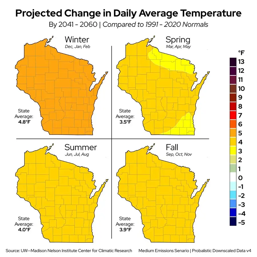
Seasonal daytime highs and nighttime lows are expected to increase by three to four degrees, except for winter. Winter lows may warm slightly more — by five to six degrees — compared to winter highs, which are projected to rise around four degrees by 2041.
More Hot Days and Warm Nights
Historically, America’s Dairyland has not seen an increase in extremely hot days, averaging about 9 days per year (1991 to 2020) with temperatures at or above 90 degrees.
By mid-century, the statewide average could triple to about 26 hot days per year.
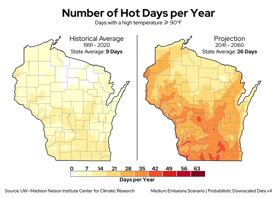
Hot days will be especially frequent in southern and western Wisconsin, while the Great Lakes help moderate summer temperatures along the coasts.
Similarly, the occurrence of warm nights (at or above 70 degrees) will increase, a trend we’re already seeing. The highest increases are anticipated in southern Wisconsin along Lake Michigan and the Mississippi River.
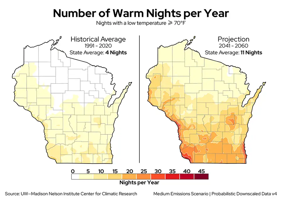
Warmer nights are driven by increased atmospheric moisture: humid air acts like an insulating blanket, holding heat and slowing nighttime cooling.
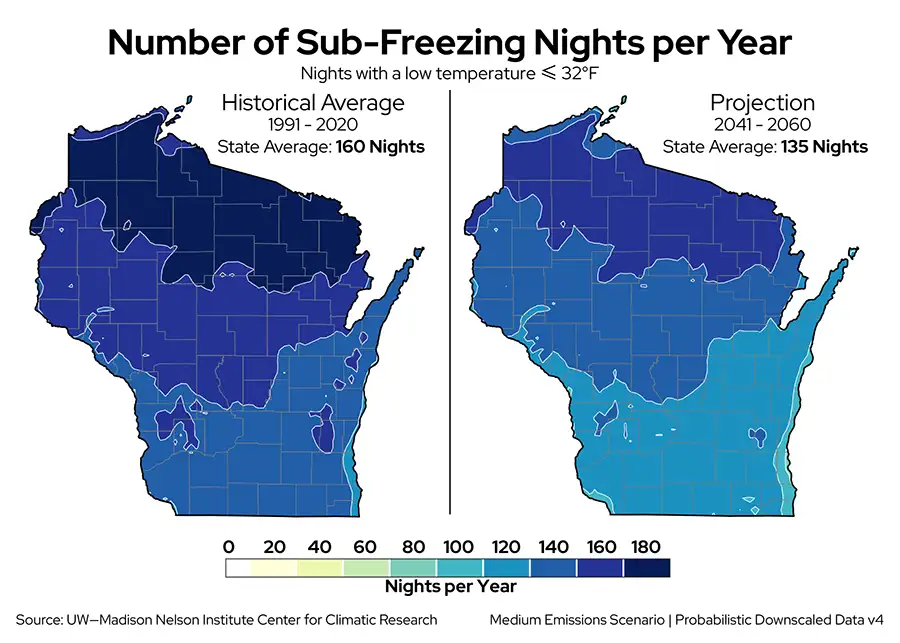
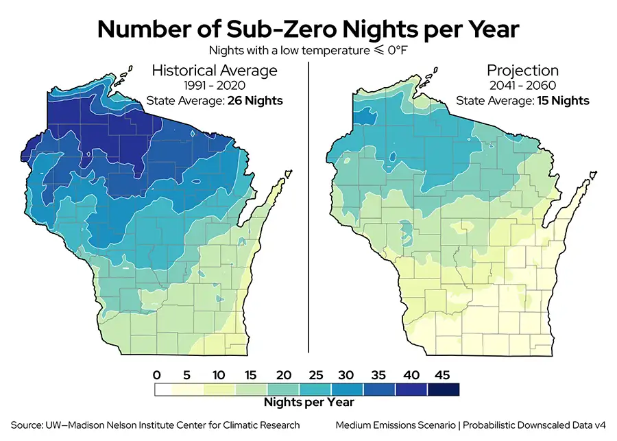
Fewer Cold Nights
As our coldest season continues to warm, frigid nights will become less common.
In the past, Wisconsin averaged about 160 nights per year at or below 32 degrees, but by mid-century, we could see roughly 25 fewer sub-freezing nights annually.
Bitterly cold nights (at or below 0 degrees), once common in the Northwoods and occasionally seen in the south, are expected to become less frequent statewide, dropping from about 26 nights per year to 15.
Shifts in Seasonal Timing
While year-to-year variability will remain, the overall trend toward prolonged warmth from spring through fall is expected to continue. Spring is likely to arrive earlier and fall later, lengthening the warm season even more than it already has.
Furthermore, unseasonable warm-ups could continue occurring in winter, as they have in the recent past (February 2024 and 2025).
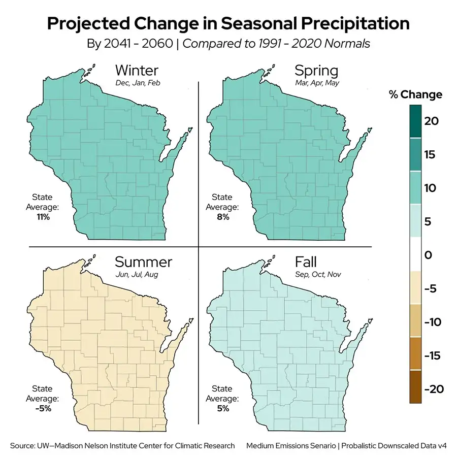
A Wetter Future Overall
As the atmosphere continues to warm, its capacity to hold more moisture increases. Think of a hot summer day, when the air often feels sticky because it can carry more water vapor than cooler days.
More moisture in the air can support more precipitation.
By mid-century, winters and springs are expected to be about 10 percent wetter than 1991 to 2020, with fall about five percent wetter. Summers, however, are expected to become about five percent drier.
Why? Climate models project a significant weakening of the jet stream during summer over nearly the entire United States. Because jet streams act as highways for precipitation-bearing weather systems, a weaker jet stream in the summer can reduce the chances for rainfall.
This matters because summer is usually Wisconsin’s wettest season and plays a key role in rebuilding moisture deficits from other seasons. Understanding how seasonal precipitation may change is an active area of climate research.
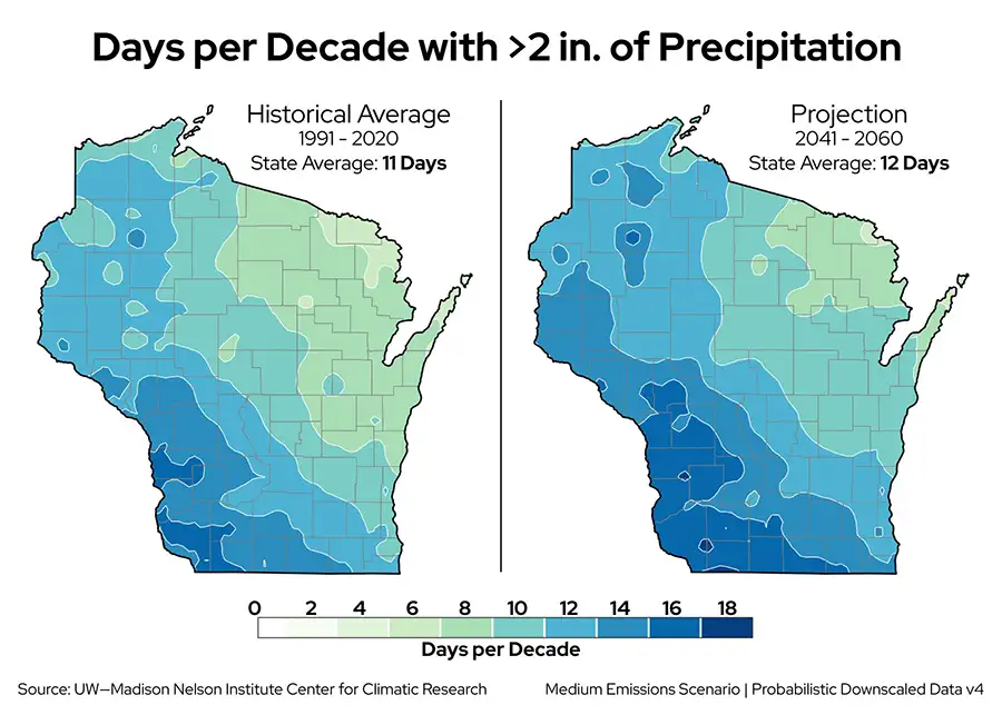
Heavier Precipitation — and Bigger Swings
It’s not just how much precipitation falls, but how intensely it falls that can have big impacts.
We will likely continue seeing more intense and more frequent heavy rainfall events. Projections show an increase in the number of days with very heavy rain (more than two inches) virtually everywhere, especially in the southern and western regions of the state.
But more frequent doesn’t mean steady.
Wisconsin and the rest of the Midwest are expected to see more back-and-forth between very wet and very dry periods. Instead of light precipitation spread across multiple days, more of it could fall in a few big events, followed by long dry stretches.
This pattern is particularly true for summer, when the vast majority of extreme precipitation occurs. Even though summers are projected to have slightly fewer rainy days overall due to a weakening jet stream, the warmer, more moisture-laden atmosphere will make the rain that does fall more intense — meaning extreme rainfall events may actually become more frequent.
Why the variability? Changes in summer atmospheric patterns — including a weaker jet stream — reduce the overall number of storms, creating longer dry periods. At the same time, a warmer atmosphere can hold more moisture, which intensifies precipitation when storms do occur. Together, these factors produce more extreme rainfall punctuated by longer dry stretches.
Where Do We Go from Here?
Understanding Wisconsin’s evolving climate is an important step toward preparing for the future. For guidance on adapting to these changes and strengthening our communities, check out the latest WICCI Assessment Report.
For a look at additional projections, see WICCI’s Trends and Projections page.
This is a product of the WICCI Climate Working Group.