In 2019, Wisconsin Act 157 provided funding through the urban nonpoint source program for flood control and riparian restoration through a flood risk reduction pilot project. In this pilot project, the DNR allocated $150,000 to Ashland County to design, implement, and evaluate three demonstration projects that test natural flood risk reduction practices. These designs were to display cost-effective nature-based approaches for restoring wetland, stream, and floodplain hydrology.
Once the projects were implemented the county provided a report summarizing the results of the demonstration projects and recommendations for how existing state policies and funding streams could be adapted to create incentives to protect and restore natural infrastructure and reduce floods. The project team also leveraged the Act 157 award to secure an additional $325,000 to complete the three demonstration projects.
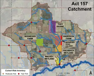
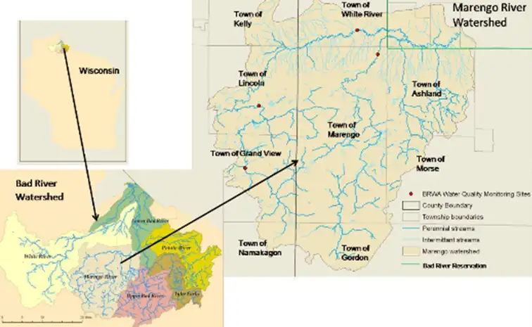
The projects took place in Ashland County, Wisconsin, within the Marengo River Watershed. The Act 157 project team chose sites concentrated within a specific catchment (upstream from the main stem of the Marengo River) to showcase how a suite of approaches could cumulatively reduce flood vulnerabilities across the landscape.
The catchment consists of multiple small drainage areas that influence the movement of water, sediment, and debris along headwater streams and associated wetlands. The outlets of this catchment significantly affect flows near high-risk culverts on the Marengo River. This specific catchment was chosen due to its degraded headwaters and repeated culvert loss during floods.
Restorations were informed by recently generated data on erosion hazards and hydrologic conditions; discussions with local landowners; and input of program managers, engineers, and hydrologists at field-based design visits. These efforts culminated in the decision to focus on the restoration of multiple hydrologically connected sites within a defined drainage area (Figure 1). Project design and permitting took multiple years.
Ashland County’s Land and Water Conservation Department led the Act 157 project in collaboration with engineering staff from the Wisconsin Department of Agriculture, Trade, and Consumer Protection; Wisconsin Wetlands Association; and other collaborators. The County was uniquely qualified for this work due to recent flood vulnerability assessments and the adoption of climate adaptation and hazard mitigation strategies focused on restoring hydrology to reduce flood risks and damages.
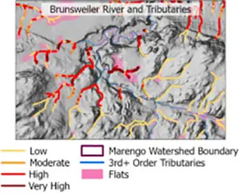
All Act 157 projects are located in the Marengo River Watershed, an area well known to be challenged by steep terrain, erodible soils, historic and current hydrologic alterations, increased annual precipitation, and a greater number of severe storms. These factors have led to erosion and loss of headwater storage and floodplain connectivity, resulting in repetitive flood damages along vulnerable road-stream crossings and farmlands. (Figure 3)
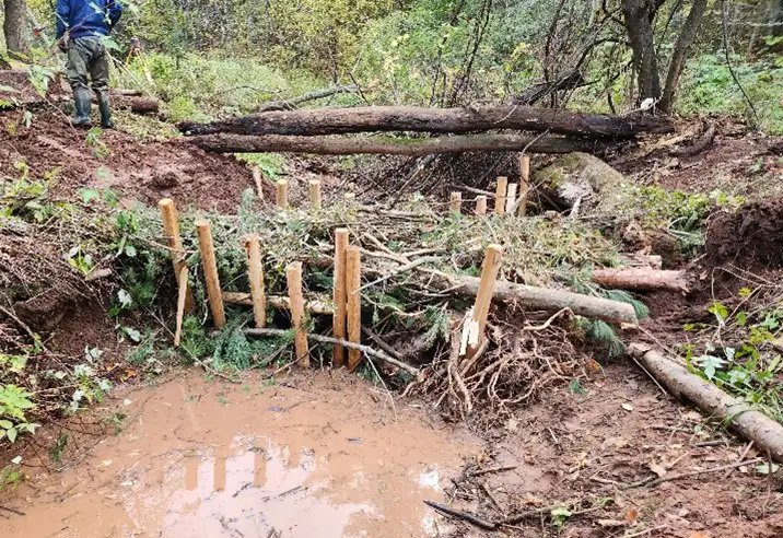
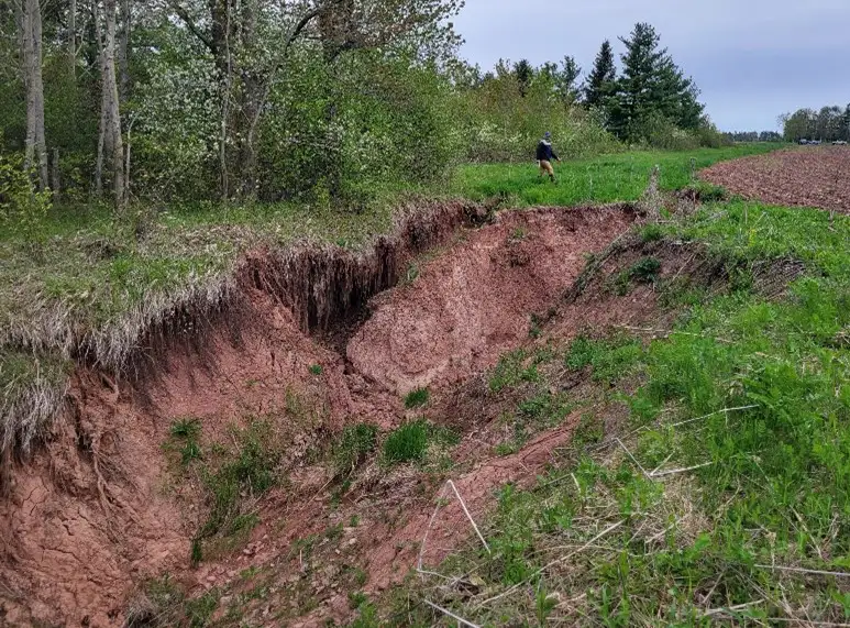
The first Act 157 project, the “Tody Ravine Headwaters Repair,” was completed in 2023 and focused on reconnecting an eroding and incising channel to its floodplain. Over time, upstream gully erosion caused sediment deposition across the valley bottom. Erosion through the deposited sediment created an unstable channel. As the unstable channel carved deeper into the valley bottom during high runoff events, floodplain disconnection increased, and flood storage decreased. The result was flashy flows, swiftly moving water, and sediment downstream and ultimately into the Marengo River.
To mitigate the gullying, the installation of channel-spanning post-assisted log structures (PALS) were selected as the low-tech approach to establish wetland, stream, and floodplain conditions that achieve project goals along the 850-foot project site. These structures were designed to capture sediment in the incised channel, lifting the grade of the channel bed to reestablish more frequent floodplain connectivity during small and large floods. Eleven PALS were installed in the project corridor. A rock riffle structure was placed at both the upper and lower portions of the channel to stabilize the project site. Angular rock was used to minimize the potential of riffle failure.
USGS deployed a Hydrologic Imagery Visualization and Information System (HIVIS) to monitor site conditions. HIVIS cameras allow USGS and the Project Team to observe the structural performance during varying flow conditions. This project reduced annual sediment loss by an estimated 439.26 tons, phosphorous runoff by 230 pounds, and captured .2 million gallons of untreated stormwater runoff per rain event. The camera images are available to view through the links below. The project area is highlighted in purple in Figure 1.
The second project, the “Fischbach Wetland Restoration,” was completed in 2023. The purpose was to restore degraded habitat and allow wetlands to slow the flow of runoff that enters the property from the north. The Fischbach Wetland is located along the flow pathways downstream of the completed Tody Ravine, the Berweger Farm projects, and the proposed Anderson Farm projects. Many times per year, flashy sediment-laden flows pass through the property in route to the Marengo River. The flows entering the Fischbach Wetland were more frequent and intense in recent years due to an upstream culvert barrier.
Flows that previously moved east under Berweger Road into a large wetland complex now divert south, through the Anderson Farm and into the Fischbach Wetland. Before this project was completed, the ditching of an ephemeral stream running through the property and other disturbances to the Fischbach wetland prevented this site from slowing the flow from upstream floodwaters.
The projects implemented included constructing five in-line wetland scrapes along an ephemeral stream to provide wildlife habitat, capture runoff, and slow the flow. A berm was constructed to distribute flows through the wetlands and to prevent head-cutting. An undersized (18-inch) culvert was replaced with a rock spillway to improve hydrologic connections to adjoining wetlands. This project reduced annual sediment loss by an estimated 11.28 tons, phosphorous runoff by 25.29 pounds, and captured .88 million gallons of untreated stormwater runoff per rain event. This project area is highlighted in orange; Figure 1.

The final project, the “Berweger Farm Gully Stabilization,” was competed in 2024. The purpose was to mitigate a severe gully, improve soil health, and reduce flashy runoff and sediment loads from a large, eroding ravine encroaching on cropland. A large gully on the west edge was head-cutting into a crop field. Gully expansion occurred several times per year following floods. As a result, flashy runoff flows passing through the gully delivered sediment-laden water downstream. Upstream, recent roadwork on County E and Highway 112 diverted flows into the western portion of this site, exacerbating gully expansion and disruption to land productivity.
A combination of hydrologic restoration practices was selected for the Berweger Farm to improve soil health, and enable the landscape to cope with, and endure extreme weather events. A wetland scrape and water control structure were constructed at the upper edge of the field to manage ditch flows entering the site and to support on-farm water management. A grassed waterway was created to stabilize an eroded agricultural ditch and manage flows from the wetland scrape to the downstream stream corridor.
A Zuni Bowl was constructed at the outlet of the grassed waterway and the head of the severe gully to dissipate energy and create steps within the eroded ravine channel. A Zuni Bowl is a low-profile “Zeedyk,” or grade control structure, made of rock to capture sediment and restore headwater wetlands impacted by head-cutting, gully erosion, and channel incision. Lastly, a rock-lined waterway and apron were installed to stabilize the grade of the eroding ravine. This project reduced an estimated 194 tons of sediment loss and 146 pounds of phosphorus runoff annually. This project is highlighted in green in Figure 1.
Additional projects on sites adjacent to the Act 157 demonstration projects have been identified as priorities for future funding applications to expand this work.
