Nick Miller is the Director of Science and Strategy at The Nature Conservancy in Wisconsin
Who are you/what is your role?
The Nature Conservancy’s (TNC) mission, around the world, is to conserve the lands and waters on which all life depends. Here in Wisconsin, we’re taking on four key strategies to achieve that mission. We’re continuing to build on our sixty-year history of protecting Wisconsin’s lands and waters, helping to ensure that wildlife and wild places continue to thrive. We’re seeking ways for Wisconsin’s working lands to provide food and water sustainably, partnering with farmers on innovative approaches to agriculture for clean waters and healthy soils. As part of our build healthy cities initiative, we’re starting a new program to complement partners’ work in Milwaukee to equitably provide access to nature, and nature’s benefits. Finally, we’re advancing the power of nature to tackle climate change, protecting and restoring habitats to capture and store carbon. These same efforts help communities adapt to climate change by reducing flooding problems and purifying waters.
To be successful, all these strategies must be founded on the best available science. As science and strategy director at The Nature Conservancy in Wisconsin, my role is to support our team as we seek this science—collaborating with researchers, conservation practitioners, and experts from agencies, organizations, and academia.
The Wisconsin Initiative on Climate Change Impacts provides an excellent example of collaboration, bringing together scientists, decision-makers, conservation practitioners, and the people of Wisconsin. By working together to build knowledge and solutions, WICCI is helping us all prepare for the changes that are coming. The Nature Conservancy is proud to participate in this collaborative effort.
Much of the knowledge TNC gains through collaborations is translated into tools—online, interactive maps that guide where and how we can work to best achieve our goals. A great example is the Resilient and Connected Network
What is the Resilient and Connected Network?
The Resilient and Connected Network provides a vision—in map format—of where we can preserve, manage, and restore lands in ways and places that provide resilience to climate change. By “resilience” we mean the ability of our landscapes to support healthy habitats and wildlife populations, despite all the impacts that come with a changing climate. Not all places have the same level of resilience. The mapping tool focuses in on places that are most likely to support a range of species’ needs, and that are connected so that species can reach and move among them.
This is a nationwide mapping tool that was built, region by region, with the input and regional expertise of scientists from many universities, agencies, and organizations. In the mountainous ecoregions of the eastern and western United States, resilience is often associated with maintaining connectivity across elevation gradients. Here in the Upper Midwest, moisture gradients influence resilience (from lakes and streams, to wetlands, to rich forests, to dry slopes).
Who can benefit from using this tool?
First and foremost, wildlife and habitats will benefit. As the climate changes, species will be able to move across the landscape and find suitable places to thrive. People will also benefit. Nature has always been our life support system, and this becomes ever more important as our climate changes and people and communities are stressed. In the eastern United States, a recent analysis (unpublished data) revealed that the benefits people derive from the Resilient and Connected Network are very high relative to non-resilient lands. Although the Resilient and Connected Network covers about twenty-five percent of the eastern United States, these same lands store fifty-six percent of all above-ground carbon (3.9 billion tons). They provide seventy-five percent of high value source water, mitigate 1.3 million tons of pollution each year (resulting in $913 million in avoided healthcare costs), and generate about $25 billion from recreation. A similar study will soon be conducted nationwide, helping to understand and communicate benefits of maintaining resilience in Wisconsin.
In addition, all of us who support and do conservation will benefit. This mapping tool points us toward sites that can remain viable through an uncertain future, and therefore helps to ensure we’re investing limited resources for conservation in places that can withstand the test of climate change. The tool will help to increase conservation efficiency and effectiveness.
How can land managers use this tool and what are the benefits in terms of climate resiliency?
The field of conservation science has come a long way. Sixty years ago, science-based conservation led us to protect individual parcels of land containing threatened species. While this remains important, we now know that those parcels must be surrounded by larger expanses of habitat to remain viable. And corridors of natural lands connecting key habitats are necessary to keep the diversity of life flowing among them.
The Resilient and Connected Network can be used by land managers to understand, protect, and manage sites with respect to the surrounding landscape, given climate change. It enables conservation practitioners to channel resources toward sites most likely to remain resilient as the climate changes. Where one resilient site lacks a connection to others, land managers may opt to restore connectivity by re-establishing forests, prairies, or wetlands.
How is the mapping tool being used?
Landmark Conservancy—one of Wisconsin’s largest land trusts, serving twenty counties in northwestern Wisconsin—recently used Resilient and Connected Network maps to determine where they can reach out to landowners to protect and increase northwestern Wisconsin’s resilient lands. Landmark’s work provides an excellent example of how resilience and connectivity maps can be integrated with other priorities and goals conservation organizations may have.
Through TNC’s partnership with Gathering Waters, which supports more than forty member land trusts in Wisconsin, we are engaging additional land trusts to aid in promoting resilience and connectivity goals.
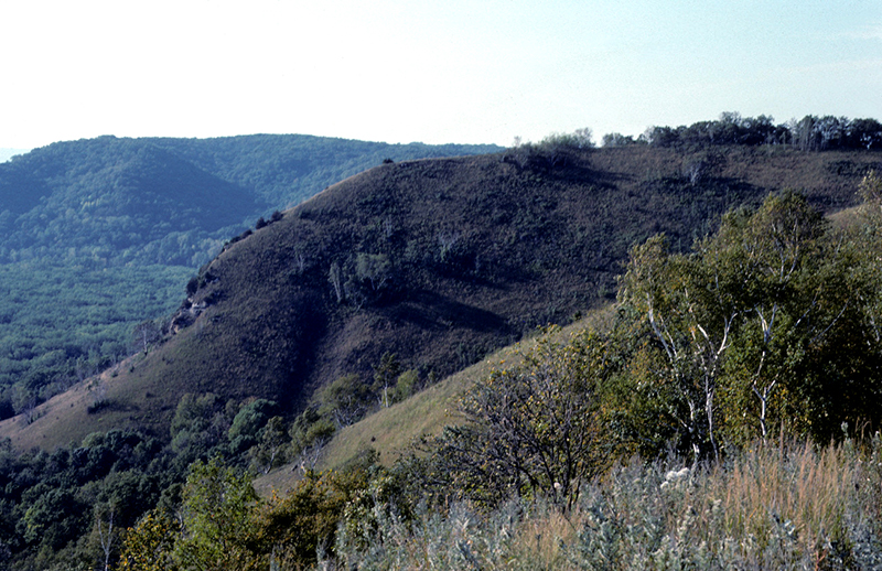
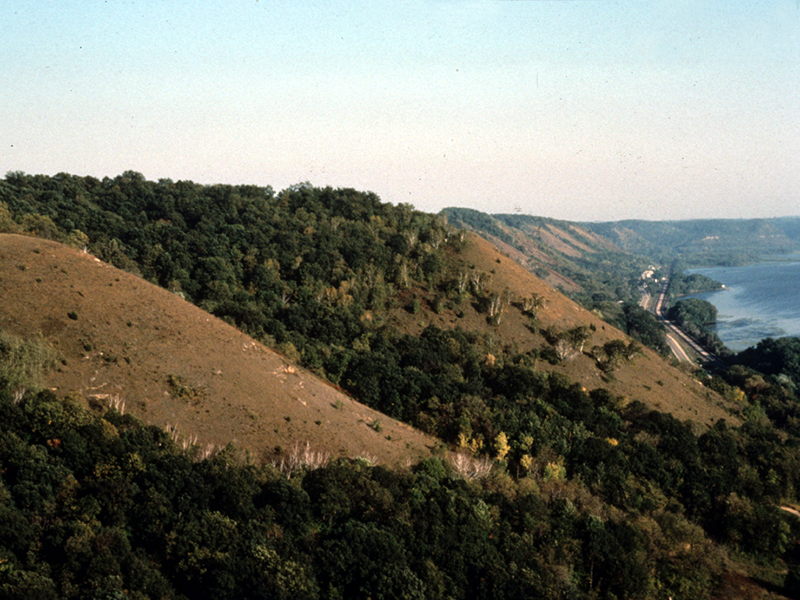
Many important parts of the Resilient and Connected Network are already protected and well-managed. Rush Creek State Natural Area, owned and managed by the Wisconsin Department of Natural Resources, provides a superb example of resilience and connectivity. It provides opportunities for species to move upslope and along streams as climate changes, it is well-connected through its location along the Mississippi River corridor, and it has diverse landforms that provide an array of niches for species to survive. The mapping tool ranks Rush Creek State Natural Area well above average for both resilience and connectivity. The mapping tool can help identify additional sites that, if well-managed like Rush Creek, can contribute to a resilient Wisconsin.
The Nature Conservancy looks forward to working with our state’s conservation organizations, agencies, tribes, landowners, and others who may consider using these maps. By working together and sharing a vision for our landscape, we can ensure a resilient, connected, and healthy Wisconsin.
Do you have hope for the future?
Yes, definitely. I feel incredibly fortunate to work with a group of people at TNC—and with WICCI and the rest of Wisconsin’s conservation community—who are dedicating their lives to figuring out how to tackle big problems like climate change. There are so many innovative conservation approaches being developed and underway. Wisconsin has the urgent need and the potential to make this happen. It’s going to take a monumental effort—with all of us working together to stop emitting greenhouse gases and start adapting to changes—and we’re already taking the first steps.
There are so many people thinking and acting on climate change from different angles. Stitch all of those together, and you have a vision for the future.
Learn More
The Nature Conservancy’s Resilient and Connected Network project is the first effort to comprehensively map resilient lands and climate corridors across the United States.
Additional Resources
The views and opinions expressed in this interview are those of the authors and do not represent official policy or position of the University of Wisconsin-Madison or the Wisconsin Initiative on Climate Change Impacts.
For More Information
Nick Miller
Director of Science and Strategy
The Nature Conservancy in Wisconsin
633 W. Main St.
Madison, WI 53703
(608) 316-6425
nmiller@tnc.org